by Lambert Wanninger, lambert.wanninger@tu-dresden.de
11 June 2004, last modification 16 June 2008
Centimetre-level accuracy positioning in real-time based on GPS measurements (or more generally on GNSS measurements) was developed in the mid-1990s and is nowadays referred to as RTK ("real-time kinematic") positioning. It involves a reference receiver transmitting its raw measurements or observation corrections to a rover receiver via some sort of data communication link (e.g., VHF or UHF radio, cellular telephone). The data processing at the rover site includes ambiguity resolution of the differenced carrier phase data and coordinate estimation of the rover position.
One significant drawback of this single base RTK approach is that the maximum distance between reference and rover receiver must not exceed 10 to 20 kilometres in order to be able to rapidly and reliably resolve the carrier phase ambiguities. This limitation is caused by distance-dependent biases such as orbit error, and ionospheric and tropospheric signal refraction. These errors, however, can be accurately modelled using the measurements of an array of GNSS reference stations surrounding the rover site. Thus, RTK positioning is extended from a single base to a multi-base technique.
The success of RTK positioning in recent years resulted in the establishment of RTK positioning services which supply reference data to anybody who is willing to pay for them. In order to provide such a service to a larger region or a whole country many reference stations have to be set up and maintained. Here, the development of Network RTK resulted in a tremendous reduction of the investment costs necessary to start an RTK positioning service, since the number of reference stations can be reduced from about 30 reference stations per 10,000 square kilometres for single base RTK to 5 to 10 reference stations per 10,000 square kilometres for Network RTK.
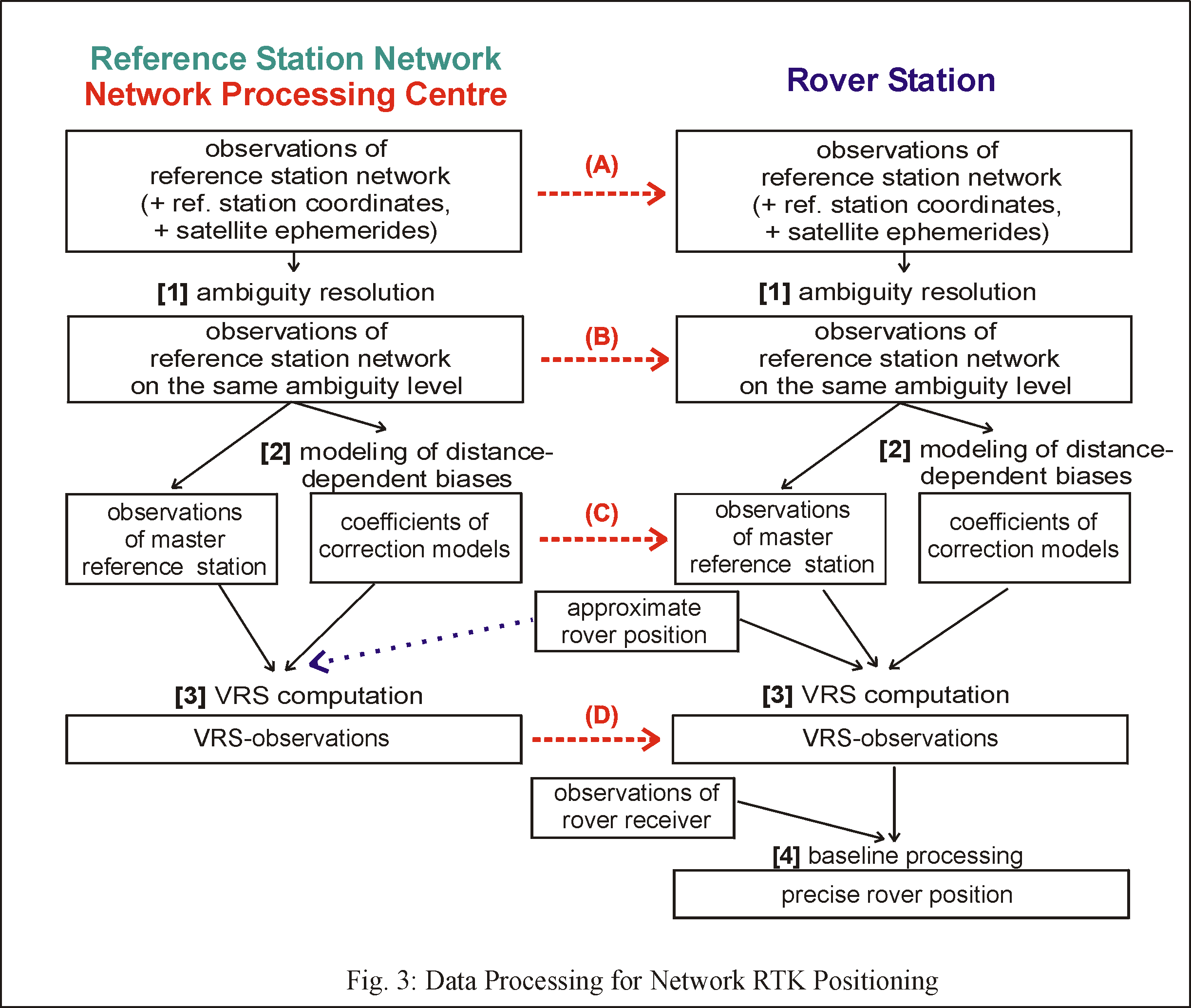
The data processing for Network RTK positioning consists of three distinct steps. In the first processing step ambiguity fixing is performed in the reference station network (cf. [1] in Fig. 3). Only observations with fixed ambiguities can be used for the precise modelling of the distance-dependent biases. The rather long distances between the reference stations (50 ... 100+ km) and the requirement to fix the ambiguities in real-time makes this processing step the main challenge of Network RTK. This network ambiguity resolution differs considerably from common RTK ambiguity resolution since the station coordinates are precisely known. All difficulties are caused by observation errors and all a-priori information which is able to reduce these errors should be used: IGS predicted satellite ephemerides, ionospheric and tropospheric corrections based on recent results of the network processing, carrier phase multipath corrections from the evaluation of past network data, and antenna phase centre corrections from antenna calibrations.
 In
the second processing step correction model coefficients are estimated
(cf.
[2] in Fig. 3). Several techniques have been developed to model
(or interpolate) the distance-dependent biases between reference stations
and user receivers. For an overview of the algorithms see (Ref.
1) and (Ref. 3). Ionospheric and orbit biases must
be modelled individually for each satellite. Tropospheric corrections,
however, may be estimated station by station. It is advantageous to separate
the dispersive (ionospheric) biases from the non-dispersive biases (orbit
and troposphere, sometimes referred to as "geometric"), since ionospheric
errors show much larger temporal variations as compared to the other distance-dependent
biases. Thus, ionospheric corrections must be updated (transmitted to the
user) more often, in practice e.g. every 10 seconds as compared to every
60 seconds for orbit and tropospheric corrections. Furthermore, in order
to be able to correct for small-scale features of ionospheric refraction
the modelling area should be kept small, i.e. ionospheric correction models
may be based on the observations of just three surrounding reference stations.
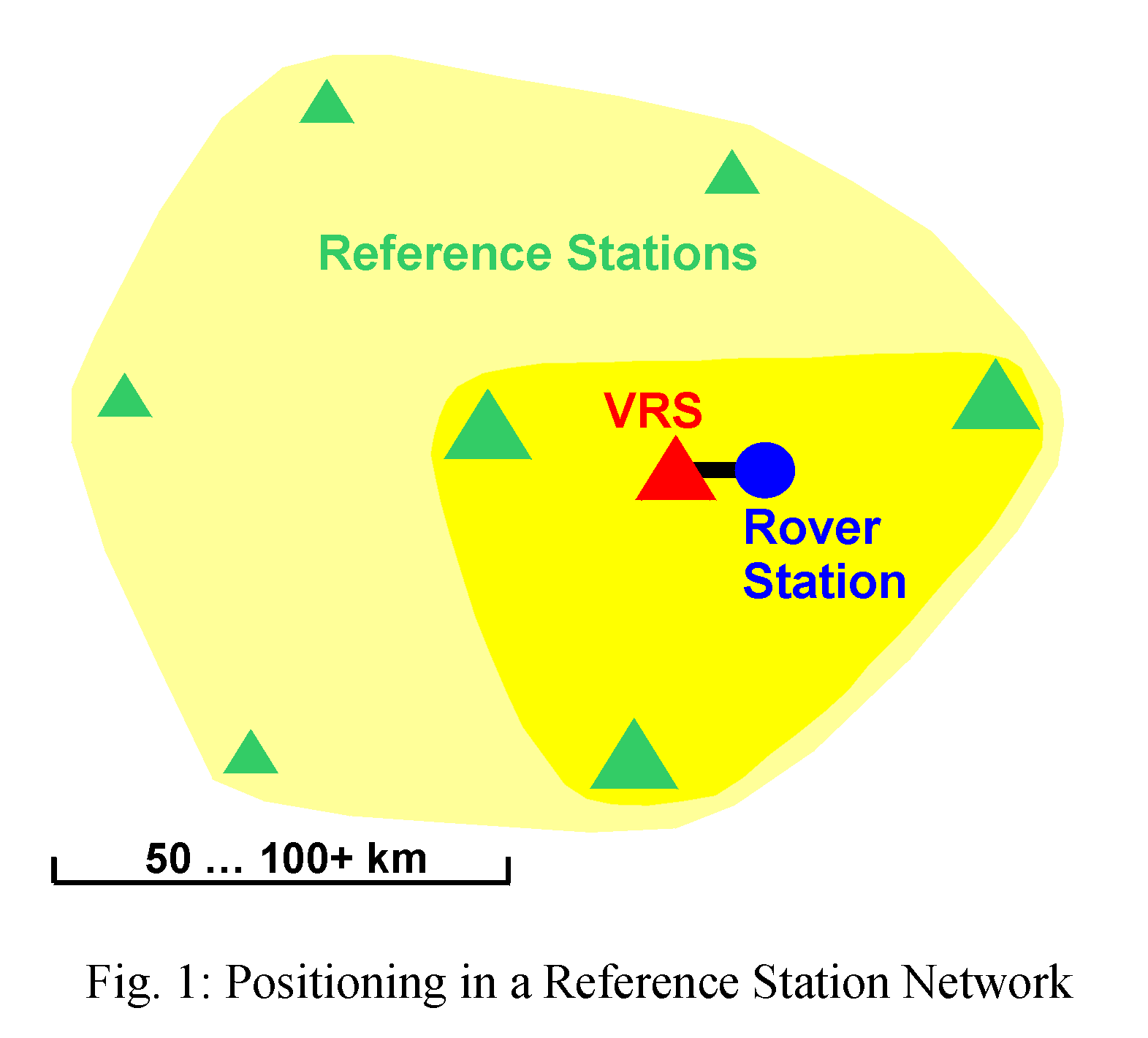
On the other hand the quality of the geometric correction models improve
when a larger number of reference stations is used (Fig. 1).
In
the second processing step correction model coefficients are estimated
(cf.
[2] in Fig. 3). Several techniques have been developed to model
(or interpolate) the distance-dependent biases between reference stations
and user receivers. For an overview of the algorithms see (Ref.
1) and (Ref. 3). Ionospheric and orbit biases must
be modelled individually for each satellite. Tropospheric corrections,
however, may be estimated station by station. It is advantageous to separate
the dispersive (ionospheric) biases from the non-dispersive biases (orbit
and troposphere, sometimes referred to as "geometric"), since ionospheric
errors show much larger temporal variations as compared to the other distance-dependent
biases. Thus, ionospheric corrections must be updated (transmitted to the
user) more often, in practice e.g. every 10 seconds as compared to every
60 seconds for orbit and tropospheric corrections. Furthermore, in order
to be able to correct for small-scale features of ionospheric refraction
the modelling area should be kept small, i.e. ionospheric correction models
may be based on the observations of just three surrounding reference stations.
On the other hand the quality of the geometric correction models improve
when a larger number of reference stations is used (Fig. 1).
 In
the third processing step of network RTK (cf. [3] in Fig. 3) an
optimum set of reference observations is computed from the observations
of a selected master reference station, e.g. the one closest to the rover
receiver, and the precise correction models for distance-dependent biases.
Based on the correction models and horizontal coordinate differences between
master reference position and approximate rover position, the reference
observations are virtually shifted to the rover site. This results in Virtual
Reference Station (VRS) observations (Ref. 7) which
are used by the rover receiver to determine his position from the processing
of the short baseline to the VRS (cf. [4] in Fig. 3).
In
the third processing step of network RTK (cf. [3] in Fig. 3) an
optimum set of reference observations is computed from the observations
of a selected master reference station, e.g. the one closest to the rover
receiver, and the precise correction models for distance-dependent biases.
Based on the correction models and horizontal coordinate differences between
master reference position and approximate rover position, the reference
observations are virtually shifted to the rover site. This results in Virtual
Reference Station (VRS) observations (Ref. 7) which
are used by the rover receiver to determine his position from the processing
of the short baseline to the VRS (cf. [4] in Fig. 3).
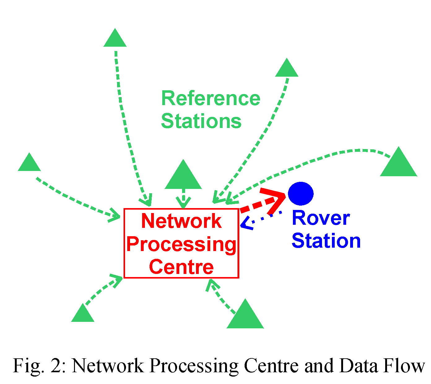
Existing Network RTK positioning services run one or more network processing centres where the reference station observations are gathered and are pre-processed. The data processing consists at least of real-time ambiguity resolution of the network carrier phase observations. This goes along with a rigorous quality control of the data. Furthermore, the spatial stability of the reference station antennas is controlled based on the gathered observations. More processing steps may be performed in the processing centre, depending on selected communication links and data formats for transmitting the network data to the user.
Figure 3 depicts four selected ways of how to transfer network information to the user. These approaches differ with respect to allocation of the processing steps either to the network processing centre or to the rover. This affects the information content and the data formats of the messages to be transmitted to the rover, and also the selection of appropriate communication channels. Methods (C) and (D) are in practical use, whereas method (B) has been tested. More methods have been discussed in recent years.
- (A) Observations of several reference stations: The rover station receives the RTCM data streams (Ref. 5) of several reference stations surrounding his position. After ambiguity resolution of the network data, the rover is able to compute network corrections and even VRS-observations to be used for the positioning of his own. The major drawback of this method is related to the ambiguity resolution of the network observations which usually requires an initialization time of several minutes.
- (B) Network observations on common ambiguity level: Broadcast of observations of a master reference station and observation differences between auxiliary reference stations and master reference station, all being on the same ambiguity level. The user performs the interpolation step on his own and thus obtains network corrections and valuable information on their quality. He is then able to compute VRS-observations and afterwards his position in baseline mode. The necessary data format is part of the RTCM-format Version 3.1 (Ref. 2, Ref. 6).
- (C) Coefficients of correction model: Broadcast of observations of a master reference station and coefficients of the correction models of distance-dependent biases. The user applies the correction models to the reference station observation data set according to the coordinate differences between his position and the position of the master reference station, and thus he obtains VRS-observations for his site. The necessary data formats have not been standardized yet, although a manufacturer agreement exists on an RTCM Version 2.3 Type 59 proprietary message containing such information (Ref. 5, Ref. 8).
- (D) Virtual Reference Station (VRS) observations: The user sends his approximate position to the central computing facility and by return receives VRS observations (RTCM Versions 2.1-2.3 or 3.0-3.1 (Ref. 5, Ref. 6)) to be used for baseline positioning. Nowadays, this is the most widely used method for Network RTK positioning because there is no requirement for an upgrade to the user equipment software. But, this method has the drawback that in general no information can be provided on the quality of the interpolation process and thus on the quality of the VRS reference observations. Furthermore, this approach requires a two-way communication link between network processing centre and rover receiver.
Real-time processing of network reference data is able to provide much more valuable information than just reference observations for RTK positioning. An important by-product is the monitoring of local crustal deformations at the reference sites. Further by-products are produced from the observed differential tropospheric and ionospheric signal delays.
In recent years first-generation Network RTK services have been developed and they have been established in several countries. These services have proven the practical feasibility of the Network RTK technique and they gained wide acceptance by the user community. Network RTK is emerging as the leading method for precise satellite-based positioning. Based on these experiences the development of second-generation Network RTK systems is under way which will make use of improved algorithms and new transmission standards. A wide range of ongoing and anticipated research is related to Network RTK. Research topics are:
- hierarchical network design: the contribution of global and regional real-time networks to small-scale Network RTK services
- content and format of Network RTK correction messages: Virtual Reference Station (VRS) concept versus broadcast Network RTK concepts
- substitution of observation corrections (RTK) by state space information (PPP Precise Point Positioning)
- improvement of algorithms for the prediction of atmospheric corrections
- mitigation of station-dependent errors (mainly multipath) at the reference stations
- development of quality indicators for network RTK corrections either from the correction computation itself or based on the observations of additional monitor sites
- new data communication systems (e.g. internet-based, or Digital Audio Broadcast)
- inclusion of the future third GPS frequency and the future Galileo system
- extraction and processing of Network RTK by-products: tropospheric and ionospheric delays, local crustal deformations.
References and Further Readings
(Ref. 1) Dai, L., Han. S., Wang, J., Rizos,
C. (2001): A Study on GPS/GLONASS Multiple Reference Station Techniques
for Precise Real-Time Carrier Phase-Based Positioning. ION GPS 2001, 392-403
(PDF
file, 795 kB)
(Ref. 2) Euler, H.-J. (2005): Reference Station
Network Information Distribution, IAG Working Group 4.5.1: Network RTK
(HTML
file, 179 kB)
(Ref. 3) Fotopoulos, G., Cannon, M.E. (2001):
An Overview of Multiple-Reference Station Methods for cm-Level Positioning.
GPS Solutions, Vol. 4, No. 3, 1-10
(Ref. 4) Rizos, C. (2003): Network RTK Research
and Implementation - A Geodetic Perspective. Journal of Global Positioning
Systems, Vol.1, No.2, 144-150 (PDF
file, 314 kB)
(Ref. 5) RTCM (2001): RTCM Recommended Standards
for Differential GNSS (Global Navigation Satellite Systems) Service, Version
2.3, RTCM Standard 10402.3 (RTCM
webpage)
(Ref. 6) RTCM (2006): RTCM Recommended Standards
for Differential GNSS (Global Navigation Satellite Systems) Service, Version
3.1, RTCM Standard 10403.1 (RTCM webpage)
(Ref. 7) Wanninger, L. (2003): GPS on the
Web: Virtual Reference Stations (VRS), GPS Solutions, 7:143-144 (HTML
file, 10 kB)
(Ref. 8) Wübbena, G., Bagge, A. (2002):
RTCM Message Type 59-FKP for transmission of FKP, Version 1.0, Geo++ White
Paper 2002.01
(PDF
file, 60kB)