| by | Israel Kashani, The Ohio State University and Technion - Israel Institute of Technology, kashani.i@gmail.com, |
| Pawel Wielgosz, The Ohio State University and University of Warmia and Mazury in Olsztyn, Poland, | |
| Dorota Grejner-Brzezinska, The Ohio State University. |
15 December 2004
INTRODUCTION
The primary goal of this contribution is to analyze the influence of the double-difference (DD) ionospheric corrections latency on the instantaneous (one-epoch) ambiguity resolution (AR) in long-range RTK under typical ionospheric conditions. Instantaneous RTK is one of the most challenging topics in the contemporary precise geodetic applications (Kim and Langley, 2000); hence, a network RTK approach to instantaneous AR is currently being implemented and tested in the MPGPSTM (Multi Purpose GPS Processing Software) software. Yet, at the beginning of the session, a short initialization period (time to integer fix) is still required using network-derived atmospheric corrections. Subsequently, DD ionospheric delay correction predictions derived from the previous correctly resolved epoch were applied in order to obtain a high quality instantaneous RTK position. This method assures a successful instantaneous AR for long baselines (~100 km). Since the previous-epoch ionospheric delays are used, and instantaneous mode is applied in the algorithm, the proposed method is robust against cycle slips and gaps and still capable of producing centimeter-level RTK positions.
Different DD ionospheric delay correction latencies were simulated in
10 s increments. The AR results were compared and analyzed and the performance
of the RTK positioning was tested. The analyses show that about 90 s latency
may exist while the instantaneous ambiguities could still be resolved correctly
allowing for centimeter-level positioning. The methodology and the applied
algorithms in the network RTK module of the MPGPSTM software
are described in detail in Kashani et al. (2004a) and the results of this
study are presented in Kashani at al. (2004b).
ATMOSPHERIC CORRECTIONS
The corrections generated using data from the CORS network include tropospheric
and ionospheric delays, which may be interpolated to the rover location.
The derivation of the zero difference (ZD) ionospheric delay, provided
to the roving user, was done by decomposing the DD ionospheric delays obtained
in the network solution. The tropospheric corrections, in the form of total
zenith delays (TZD), are estimated for each reference station. The accuracy
of the atmospheric corrections provided to the rover is one of the most
crucial issues for successful AR in instantaneous long-range RTK. In this
approach we adopted two "rules-of-thumb" concerning the ionospheric correction
accuracy: first, the ionospheric correction error must be better than one
quarter of the signal wavelength (±5 cm); second, the ionospheric
correction constraints should follow the correction accuracy. The major
problem is that the network-derived atmospheric correction accuracy may
not be always sufficient and could exceed the ±5 cm limit (see also:
Odijk, 2001). Short accumulation period should be applied at the beginning
of the session, namely OTF technique, to initiate the system in order to
overcome this problem. Once the ambiguities were resolved (fixed and validated)
using the OTF technique, the instantaneous solution can be applied. In
the instantaneous step, predicted ionospheric delays, more accurate than
the interpolated ones, are provided to the rover solution. The predicted
delays are derived from the previous correctly resolved epoch and their
accuracy depends mainly on the sampling rate, their latency and the ionospheric
conditions. The smaller the sampling rate and the latency, the more accurate
predicted ionosphere corrections may be obtained. The predicted ionospheric
corrections are robust against cycle slips as long as the same pair of
stations and satellites is involved.
ANALYSES
GPS data from the GIL (GPS in Israel) network was used in this study.
With the intention to simulate a network RTK solution, three reference
stations were selected to produce network atmospheric corrections, while
one reference station was considered a rover. The distances between the
reference stations are 110, 112 and 180 km and between the reference stations
and the rover 50, 85 and 98 km, as presented in Figure 1. The station heights
(ellipsoidal) vary from 32 to 1083 m. Dual-frequency observations were
collected on June 21, 2004, with 10 s sampling rate, in four one-hour long
sessions (360 epochs per session) representing different TEC levels, starting
at:
a) 01:00 UT ( 4 am LT)
b) 09:00 UT (12 pm LT)
c) 13:00 UT (16 pm LT)
d) 17:00 UT (20 pm LT)
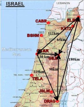
Fig. 1: The GIL (GPS in Israel) network and the test area (courtesy of the Survey of Israel).
Four scenarios were analyzed in this study:
- Analysis of the network-derived ionospheric delay corrections
- Analysis of the predicted ionospheric delay accuracy as a function of the latency
- Analysis of the AR performance as a function of the predicted ionospheric delay latency/accuracy
- Analysis of the rover positioning performance in the instantaneous mode.
AMBIGUITY RESOLUTION PERFORMANCE
The AR performance was analyzed as the percentage of the correctly resolved and validated ambiguities within each session. The AR depends on the accuracy of the ionospheric corrections provided to the rover (rule 1) and the ionospheric constraints applied in the generalized least squares (GLS) adjustment stochastic model (rule 2). The constraints applied to the DD ionospheric corrections were proportional to the correction latency: the larger the latency the less tight the constraint (e.g., 1 cm for 10 s latency and 5 cm for 90 s). Table 1 presents selected examples of the AR performance as a function of the DD ionospheric correction latency and the baseline length, obtained from the single-baseline solution.
The applied methodology allowed for 100 percent instantaneous AR success
in all the sessions when the latencies were up to 80 s, and between 95.8
and 100.0 percent, when they reached 90 s. The worst results were obtained
during the first session, characterized by higher TEC gradients just before
the sunrise, when the ambiguities were not correctly fixed in some epochs
and baselines. As expected, better results were obtained for the sorter
baseline (50 km) with only one session with few unresolved ambiguities.
However, all the ambiguities may be resolved instantaneously when the optional
multi-baseline solution is applied, as is demonstrated in Kashani et al.
(2004b).
Tab. 1: Example AR success rate (%) for all analyzed sessions,
for 50 km and 98 km baselines.
| 50 km | 98 km | ||||||||||||||||||||||||||||||||||||
|
|
|
POSITIONING ACCURACY
The results of a 98 km long single-baseline (GILB-DRAG) processing are
presented in Figure 2. Different latencies of the DD ionospheric corrections
were tested with 10 s increments and example results for 90 s latency are
shown for the mid-day session. The results presented here confirm that
the instantaneous long-range RTK methodology and algorithms applied in
the MPGPSTM software can process 100 km baselines even with
DD correction latency of 90 s (depending on the local ionospheric conditions).
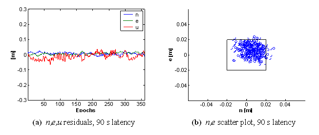
Fig. 2: RTK position residuals (n,e,u) for GILB-DRAG baseline
(98 km), session b, 09:00-10:00 UT (12-13 am LT)
SUMMARY AND CONCLUSIONS
The interpolated ionospheric correction accuracy may not sufficient
to assure a high success rate of instantaneous AR. Thus, after a short
initialization period, the DD ionospheric delays from the previous correctly
resolved epoch were used as a prediction for the current epoch. For the
existing ionospheric conditions, network configuration and the processed
baseline lengths (50 and 98 km), 90 s latency seems to be a limit for reliable
instantaneous AR. Once the ambiguities are correctly resolved, centimeter-level
instantaneous RTK positioning is assured even for ~100 km long baselines.
Slight mismodeling of tropospheric correction affects the height component
quality. However, centimeter-level accuracy is still feasible. The optional
multi-baseline approach applied in the MPGPSTM software improves
the solution in terms of the AR reliability and positioning quality. It
should be noted that the analyses were performed in the post-processing
mode. The algorithm, however, is suitable for real-time applications as
well. Naturally, for the real RTK implementation, the issue of communication
and the computing power at the rover station must be addressed properly.
REFERENCES
Kashani, I., Grejner-Brzezinska, D.A., and Wielgosz, P. (2004a): Towards instantaneous RTK GPS over 100 km distances, ION 60th AM, June 7-9, Dayton, OH, pp. 679-685
Kashani, I., Wielgosz, P., and Grejner-Brzezinska, D.A. (2004b): The Double Difference Effect of Ionospheric Correction Latency on Instantaneous Ambiguity Resolution in Long-Range RTK, ION GNSS 2004, September 21-24, Long Beach, CA, Winner of a "Best Paper Award", pp. 2881-2890
Kim, D., and Langley, R.B. (2000): GPS Ambiguity Resolution and Validation: Methodologies, Trends and Issues, 7th GNSS Workshop and International Symposium on GPS/GNSS, Seoul, Korea, November 30 - December 2, pp. 213-221 (PDF file, 85 kB)
Odijk,D. (2001): Instantaneous GPS Positioning Under Geomagnetic Strom Conditions, GPS Solutions, Vol. 5, No. 2, pp. 29-42 (PDF file, 1700 kB)
Rizos. C. (2002): Network RTK research and implementation: A geodetic perspective, Journal of Global Positioning Systems, Vol. 1, No. 2, pp. 140-150 (PDF file, 184 kB)